The Making Room for Wetlands Project began in 2017, initially wrapping up in 2022. The first edition restored key sites like Belcher Street Marsh and Converse March.
The second chapter of the project launched in 2022 and will wrap up in 2027. The project has two parts: St. Croix Edition and Coastal Carbon Edition. Get updates on each of the projects below!
Recent Restoration Projects

St. Croix Edition
Coastal Carbon Edition
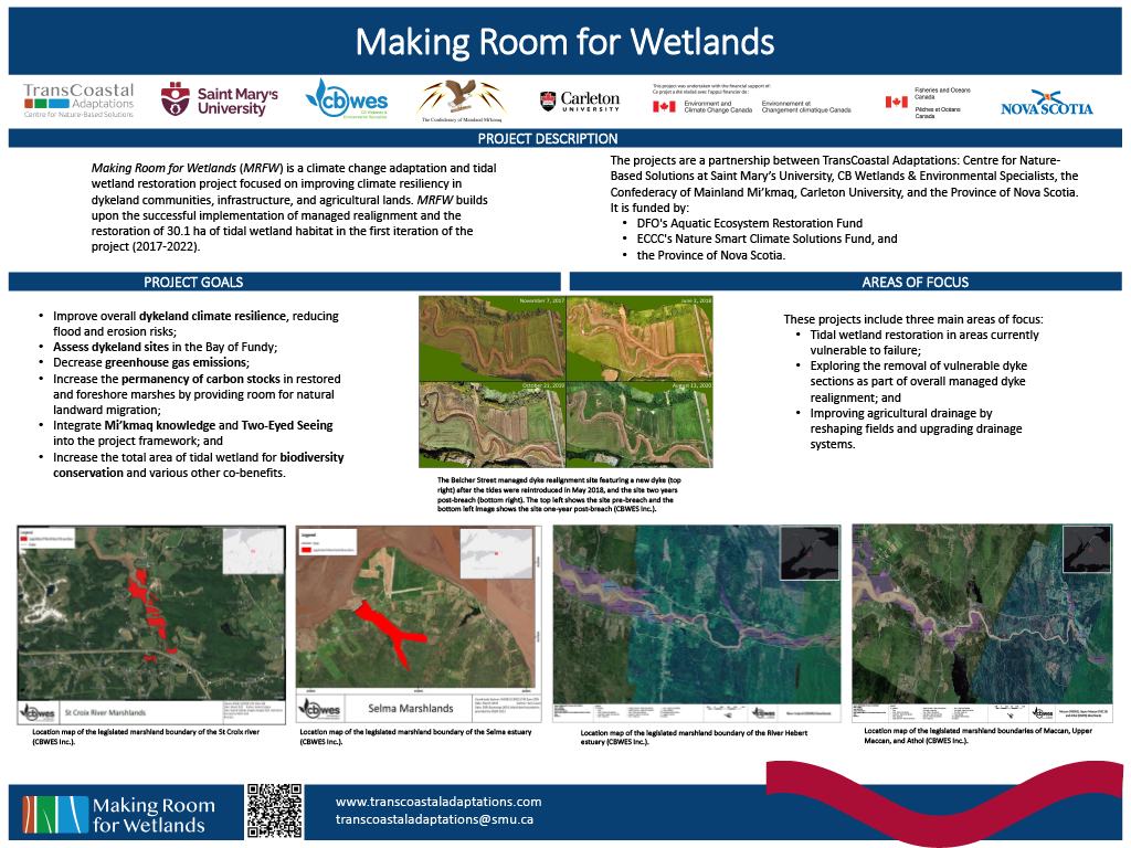
Making Room for Wetlands: Coastal Carbon Edition will employ the MRFW managed dyke realignment and tidal wetland restoration framework at underutilized, fallow and/or poorly draining dykeland sites in the Bay of Fundy.
This climate change adaptation and restoration project will reduce GHG emissions and increase carbon storage by both increasing the area of tidal wetlands through restoration, and improving drainage on poorly drained agricultural lands. The project will also increase biodiversity and improve the resilience of the surrounding dykelands to climate change by accommodating sea-level rise and reducing flood and erosion risk.
The Making Room for Wetlands: Coastal Carbon Edition is funded by the Environment and Climate Change Canada – Nature Smart Climate Solutions Fund (ECCC-NSCSF) and is a partnership between TCA at Saint Mary’s University, CBWES, NSDA and the CMM, as well as NS Public Works, NS Environment and Climate Change, and Carleton University.


FAQ’s
-
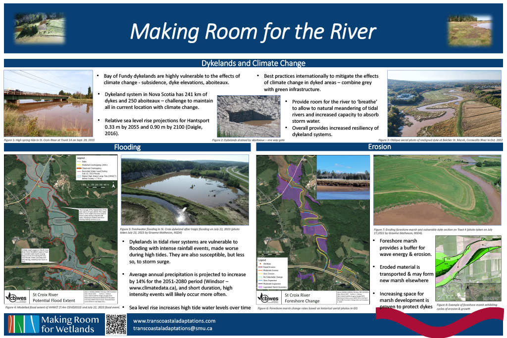
The effects of climate change include sea-level rise, and stronger and more frequent weather events. These effects can result in increased erosion, storm surge, and flooding, that some of our existing dyke infrastructure may not be able to keep up with. This puts dykeland communities in the Bay of Fundy at higher risk. Some towns, roads and agricultural lands have already experienced effects like flooding and erosion.
The best way to protect infrastructure, people, and important lands from the impacts of climate change in the future, is to take action to adapt to climate change now.
-
We know that the sea level is rising, but we also know that Nova Scotia is slowly sinking as the land settles in the wake of the last ice age. As sea level increases and Nova Scotia sinks, this means that in Nova Scotia we will see even higher water levels compared to the land (this is called relative sea level). There are different predictions (based on different climate change scenarios, etc.) but it is predicted that Nova Scotia will see a relative sea level rise of about 1 m and up to 1.2 m by 2100.
-
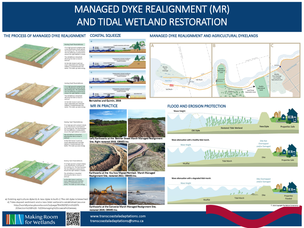
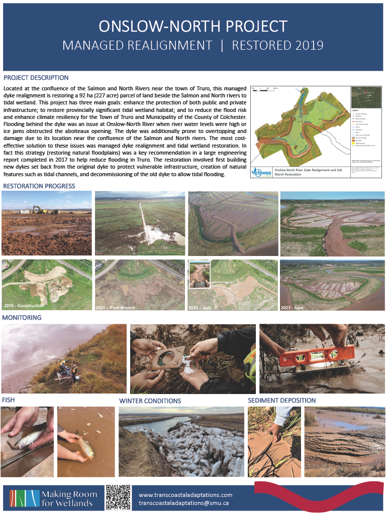
In general, managed dyke realignment (MR) is moving winding dyke infrastructure back from the water’s edge to a more low-risk location. This helps create infrastructure that is easier and less costly to maintain and provides better flood protection to the areas behind the new dyke.
The MR process could include building new, straightened dyke sections further back from the edge of the water, and then breaching or removing the old dyke infrastructure to let tidal waters return to the selected area. This allows for the strategic restoration of natural tidal wetlands that can act as the first line of defence for both dyke infrastructure, and the lands and infrastructure behind them.
-
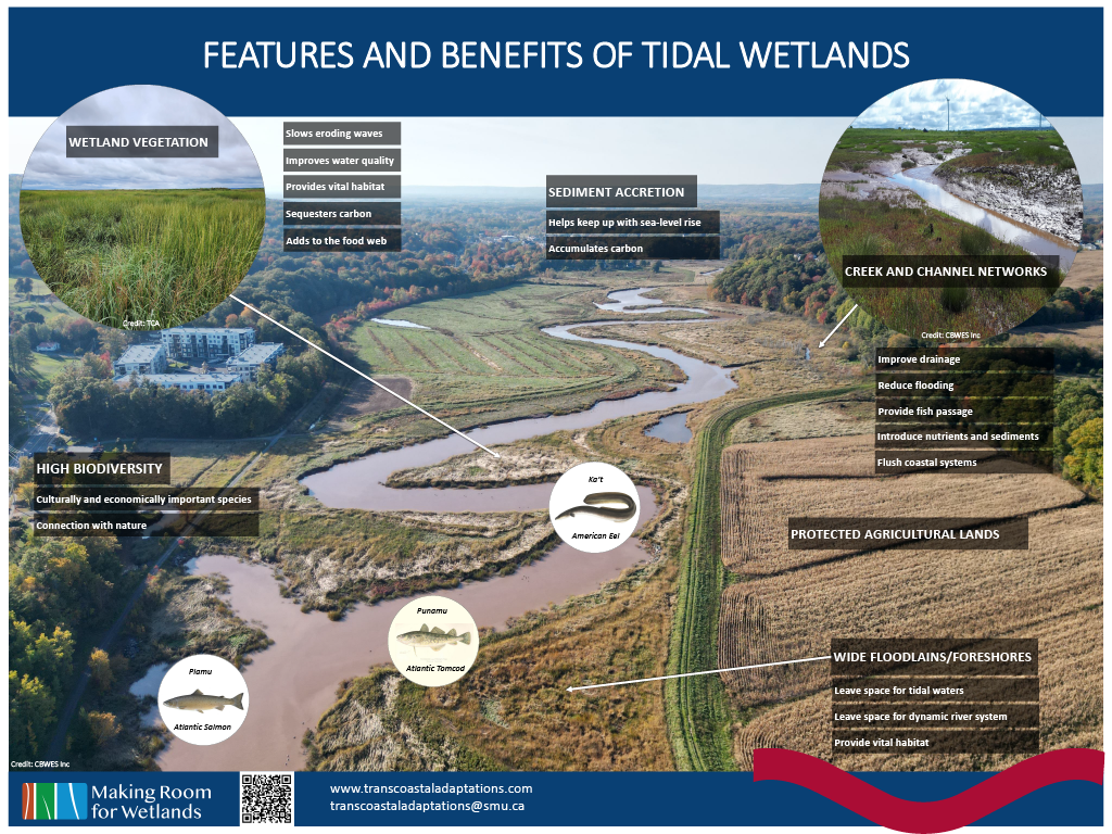
Tidal wetlands and marshes in front of dykes (called foreshore wetlands) act as the first line of defense against extreme weather events and sea-level rise. Wetlands act like a sponge by absorbing more tidal waters. Restoring wider foreshore wetlands leaves more room for the rivers to breath and reduces the water levels up against the dykes. Wetland plants also absorb wave and storm energy that erodes shorelines and dyke infrastructure.
In general, more foreshore wetland leads to lower water levels and smaller waves and means less risk of a dyke being damaged or having water spill over the top (called overtopping). By realigning dykes and restoring tidal wetlands in front of them, we are creating better defences for dykeland communities.
-
The dyke infrastructure in the Bay of Fundy is at risk to climate change effects such as flooding and erosion with strong weather events increasing in strength and frequency.
The Making Room for Wetlands project helps protect dykelands by:
1. Removing sections of dyke that are most at risk, or already failing, and building/upgrading new sections that can meet climate change standards. This reduces the amount of dyke and aboiteaux to maintain in the future and ensures new sections can stand up to water levels in the future. This leaves more resources to help maintain other dyked areas.
2. Moving infrastructure back from the water and restoring wetlands in front. This brings in a new line of defence in front of the dykes. Wetlands can absorb more water than compacted fields, and help to reduce waves and water levels that cause erosion and flooding. Wetlands in front of dykes helps to protect dyke infrastructure, and the lands that rely on them.
By realigning dykes in areas that are especially vulnerable, we are better protecting all of the remaining dyke infrastructure and lands that remain. By restoring tidal wetlands, we restore the protection services they can provide, in addition to other benefits like improved water quality and habitat, pollination services, and more.
-
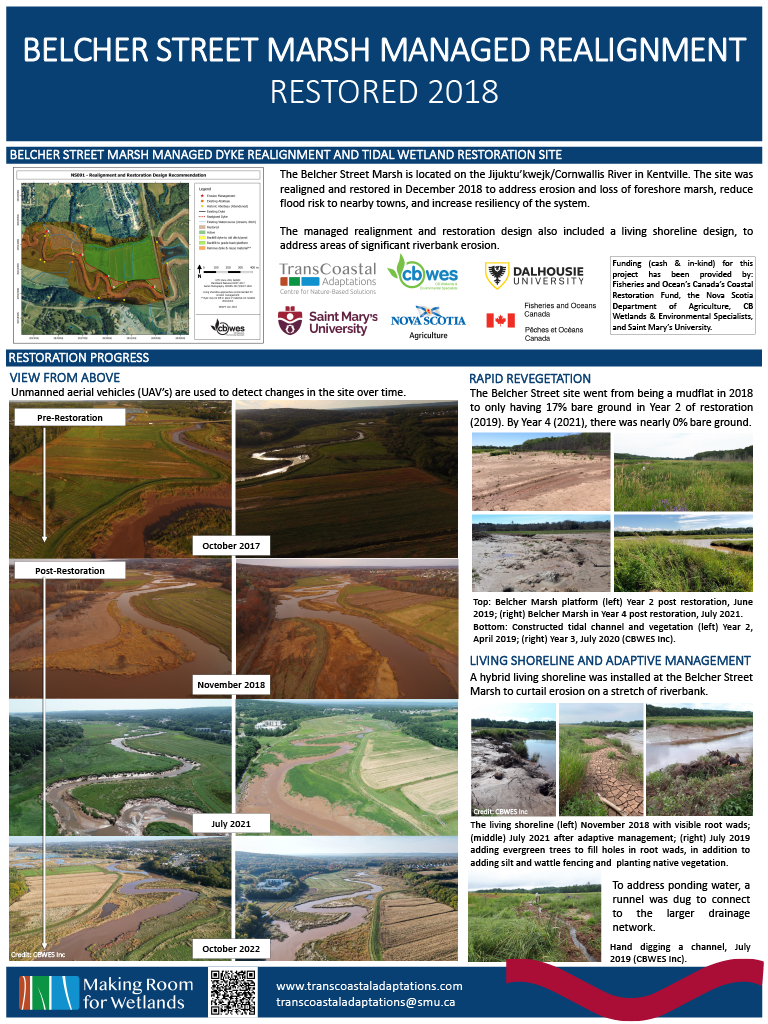
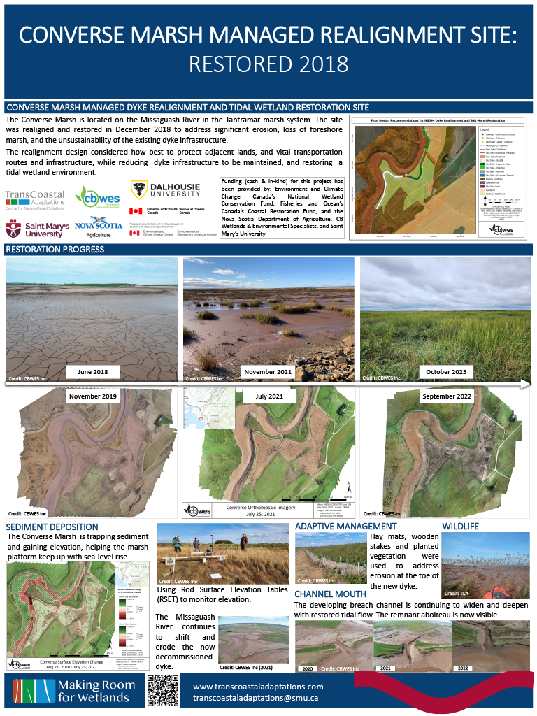
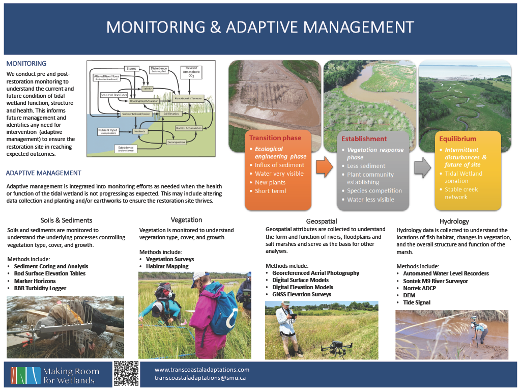
After tidal waters are allowed back into an area, the land will gradually transition back into a tidal wetland ecosystem.
1. Transition phase (approximately 3 years): In this phase, the area is being flooded with tidal waters, and lots of sediment is being deposited. This builds up the elevation of the new marsh surface. New marsh vegetation begins to emerge.
2. Establishment phase: In this second phase, there is less sediment, and new wetland vegetation begins to establish. The site begins to look less like a mud flat.
3. Equilibrium phase: As the wetland reaches equilibrium, the site is well vegetated. A stable network of creeks and tidal channels emerges.
-
The plamu (Atlantic Salmon), the punamu (Atlantic tomcod) and the ka’t (American eel) are all culturally significant species to the Mi’kmaq and rely on healthy tidal rivers and wetlands to feed, reproduce, and live. The plamu/Atlantic Salmon and the ka’t/American eel are also both either Endangered or Threatened Species in Canada. Restoring tidal wetland habitat will help the populations of these important species thrive!
-
The Department of Agriculture has 241 kms of dykes to maintain that protect critical infrastructure and agricultural lands. This work needs to be planned and prioritized.
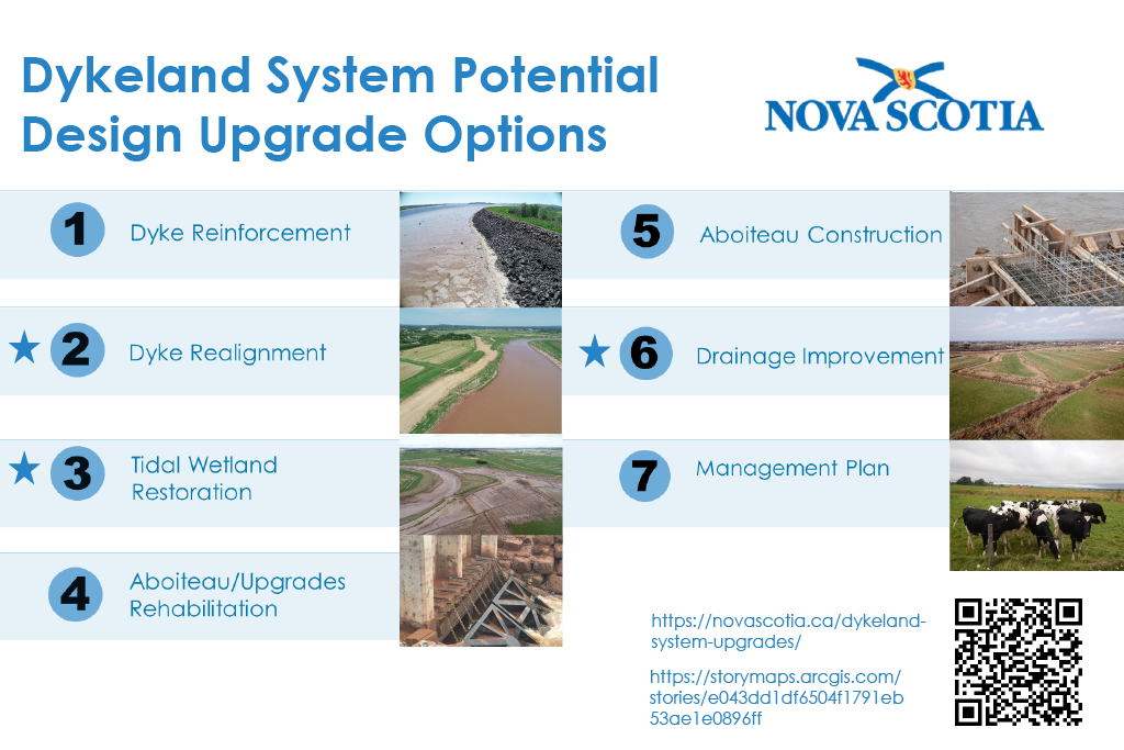
The dykeland system in Nova Scotia’s Bay of Fundy is currently being upgraded at its most vulnerable sites through another program, the Dykeland System Upgrades Program (DSUP). This program is being led by the Nova Scotia Department of Agriculture (NSDA). DSUP includes a variety of possible upgrade design options (including managed dyke realignment and tidal wetland restoration).
The dykeland sites that are being considered for the Making Room for Wetlands (MRFW) project are not the same as those that are included in the DSUP. The MRFW project is a collaborative effort involving Saint Mary’s University, CBWES Inc., the Confederacy of Mainland Mi’kmaq, and the NSDA and is complementary to the DSUP project.
While both projects consider a range of options, the MRFW project considers a smaller selection and prioritizes different upgrade options than DSUP. Both projects will inform future work in the province to mitigate the impacts of climate change
These are complex issues. There are factors that go beyond dollars including regulatory requirements, such as wildlife, fish habitat, and special places and a broader willingness to embrace long-term solutions to the challenges of climate change.
-
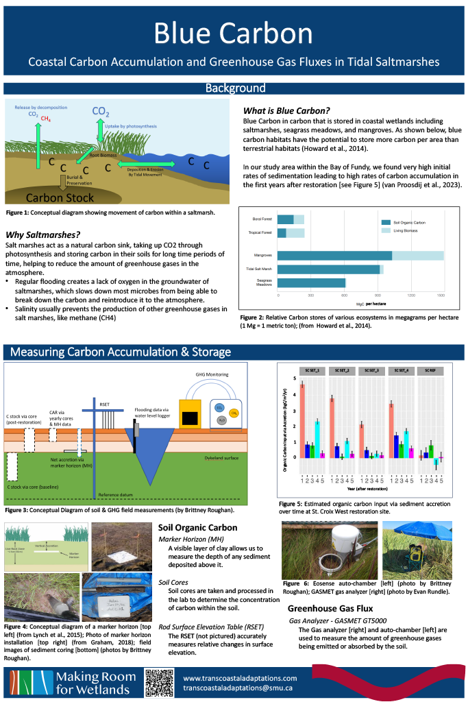
While many of the dykes and aboiteaux in the Bay of Fundy protect active and productive agricultural lands, others protect some underutilized and/or poorly draining areas. Poorly draining, compacted soils are a source of greenhouse gases such as methane and nitrous oxide.
Carbon is another greenhouse gas that contributes to climate change. Tidal wetlands are known as extremely good “carbon sinks” – this means they store more carbon than they release.
By restoring some of these areas to tidal wetlands, we can reduce greenhouse gas emissions and increase carbon storage capacity, while also seeing the other benefits that tidal wetlands provide.
-
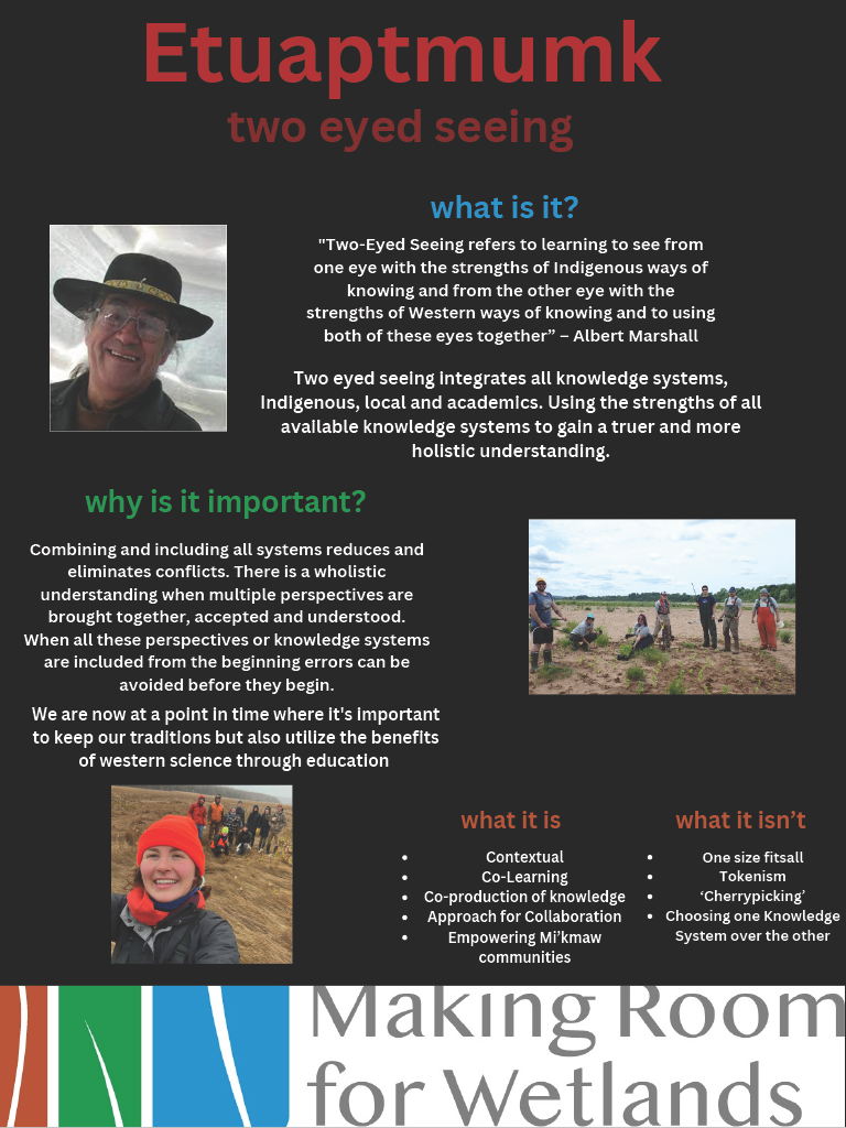
Etuaptmumk, or Two-eyed Seeing refers to “learning to see from one eye with the strengths of Indigenous ways of knowing and from the other eye with the strengths of Western ways of knowing and to using both of these eyes together” – Elder Albert Marshall (Bartlett, Marshall, & Marshall, 2012).
The Making Room for Wetlands project is continuing to build on existing relationships with the Confederacy of Mainland Mi’kmaq to strengthen the Two-eyed Seeing perspective within the Making Room for Wetlands project. By integrating traditional ecological knowledge and Mi’kmaq ways of being such as Netukulimk, we hope to:
- Strengthen the success of restored tidal wetlands.
- Further develop the MRFW managed dyke realignment and tidal wetland restoration framework as a holistic approach.
Visit the following resources to learn more:
https://www.2eyedseeing.ca/about-5
http://www.integrativescience.ca/
https://mikmawconservation.ca
-
Aboiteau(x) - A water control structure consisting of a tide gate at the end of a culvert that regulates water flow between a tidewater area and a drained upland area (NSDA).
Adaptation – “Climate change adaptation refers to actions that help reduce vulnerability to the current or expected impacts of climate change like weather extremes and natural disasters, sea-level rise, biodiversity loss, or food and water insecurity.” (UNDP, 2023)
American Eel (ka’t, Anguilla rostrata) – The COSEWIC status of the American Eel is Threatened and is pending decision for protection under SARA (GC). Ka’t are harvested year-round as both a food source and for medicinal value and it is an important species to the Mi’kmaq (Apoqnmatulti’k.ca). The American Eel is the only fish in North America that spawns in the ocean and migrates to freshwater to mature.
Atlantic Salmon (plamu, Salmo salar) – The status of the Atlantic Salmon, Inner Bay of Fundy population is Endangered (COSEWIC, SARA), and it is a protected species under the Species at Risk Act (SARA)(GC). The practice of salmon harvesting as a means of sustenance is important to the Mi’kmaq (Denny et al.).
Atlantic Tomcod (punamu, Microgadus tomcod) – The Atlantic Tomcod (also known as “winter cod” and “frostfish”) are a culturally important fish to the Mi’kmaq. They are known for their resilience to cold, migrating up tidal rivers in the fall in order to spawn during the winter months. They are an important food source, providing sustenance to communities in the challenging winter months (Apoqnmatulti’k.ca). The Mi’kmaq name for the month of January is Penamujuiku’s, which means frost fish runs.
Blue Carbon - Blue carbon is the term for carbon that is stored by oceans and coastal ecosystems such as wetlands and mangroves (NOAA).
Carbon Sequestration - Carbon sequestration is the process of capturing and storing atmospheric carbon dioxide (USGS).
Climate Change – Climate Change refers to “the long-term changes in the Earth’s climate that are warming the atmosphere, ocean and land”. While shifts in climate can be natural, modern human activities are now the main driver of climate change. (UNDP, 2023)
Dyke - An embankment constructed of earth or other suitable materials whose purpose is coastal flood risk reduction or water conveyance. Commonly referred to as a dyke, dike, levee or embankment. (NSDA)
Etuaptmumk (Two-eyed Seeing) – “refers to learning to see from one eye with the strengths of Indigenous ways of knowing and from the other eye with the strengths of Western ways of knowing and to using both of these eyes together” – Elder Albert Marshall (Bartlett, Marshall, & Marshall, 2012).
Greenhouse Gases (GHGs) – “Gases that trap heat from the sun in our planet’s atmosphere, keeping it warm. Since the industrial era began, human activities have led to the release of dangerous levels of greenhouse gases, causing global warming and climate change” (UNDP, 2023).
Global warming - “The increase in the Earth’s average surface temperature that occurs when the concentration of greenhouse gases in the atmosphere increases”. (UNDP, 2023)
Mitigation – “Climate change mitigation refers to any action taken by governments, businesses, or people to reduce or prevent greenhouse gas emissions, or to enhance carbon sinks that remove these gases from the atmosphere” (UNDP, 2023).
Nature-based solutions - “Refers to an umbrella concept for various ecosystem-related approaches. It covers actions to protect, sustainably manage and restore natural or modified ecosystems. Nature-based solutions aim to achieve resilience in ways that enhance the resilience of ecosystems, their capacity for renewal and the provision of services” (OECD, 2019).
Netukulimk - A Mi’kmaw way of life and being. It is a complex cultural concept that encompasses how a person lives in harmony with the land. While it cannot be summarized in a single phrase, it includes generally “taking what you need now and saving some for later” (Prosper, McMillan, & Davis, 2011).
Resilience – “The ability of households, communities and nations to absorb and recover from shocks, while positively adapting and transforming their structures and means for living in the face of long-term stresses, change and uncertainty” (OECD, 2019).
Sea-level rise – “The change in sea levels caused by global warming (e.g. though thermal expansion of the ocean, melting glaciers and polar ice caps, and ice loss from Greenland and West Antarctica ice sheets). The temporal average for a given location is mean sea level and the spatial average is global mean sea level. Changes in local relative sea level can vary significantly from changes in global mean sea level” (OECD, 2019).
Underutilized - In this project, underutilized lands are considered land that is vulnerable and at risk of flooding and erosion or is strategically located. Fallow areas are considered before active lands.
Wetlands – “Wetlands are areas where water covers the soil, or is present either at or near the surface of the soil all year or for varying periods of time during the year, including during the growing season.”(EPA)
Tidal Wetland – A wetland that experiences regular tidal flooding.
Informational Materials
Project Fact SHeets

MRFW: Coastal Carbon Edition Info Sheet. Click on the image to view and download full document.

MRFW: St. Croix Edition Info Sheet. Click on the image to view and download full document.
Open House Posters
Unable to make an Open House? See something you would like to have on hand? You can download all of our informational posters as a pdf here, or individually below.